Here’s How to Make Flood-Prone Areas in New Jersey More Resilient to Climate Change

Rutgers professor creates free, comprehensive guide for municipalities based on extensive research
For years, Rutgers ecologist Brooke Maslo has studied how to redesign flood-prone landscapes so they can best protect the communities they border from the ravages of swollen brooks and rivers and rising seas.
State and federal programs that enable the acquisition of flood-prone properties from willing homeowners at fair market value and then clear the land represent powerful first steps toward resilience, said Maslo, an associate professor with the Rutgers Department of Ecology, Evolution and Natural Resources in the School of Environmental and Biological Sciences (SEBS).

But how can communities transform this vacant land, so it is better able to withstand flooding and rebound when the waters recede? Maslo, a founding member of the newly established Rutgers Climate and Energy Institute (RCEI), has an answer for the leaders of all 564 of New Jersey’s municipalities.
“Creating Flood-Resilient Landscapes: A Primer for New Jersey Communities” is the product of eight years of research and practical experience by Maslo and her resilience team, which includes an interdisciplinary group of collaborators from both Rutgers, including project coordinator Kathleen Kerwin, and South Dakota State University researchers, including Jeremiah Bergstrom, Shelbie Smith, Emma Martin and Alyssa Faber.
“With more than 1,800 miles of coastline and 6,450 miles of rivers in New Jersey, much of New Jersey’s developed land is at risk of being severely affected by flooding over the next 30 years,” Maslo said. “These challenges can be overcome through resilient landscape designs, which is an ecologically centered approach that combines principles of engineering, ecology and landscape architecture with social science to transform acquired properties into public assets.”
Aided by funding from the New Jersey Department of Environmental Protection’s (DEP) Resilient NJ program and RCEI, Maslo and her interdisciplinary team have written and produced a free, comprehensive guide available online and in print.
"More New Jersey communities than ever before are grappling with severe flooding and looking for solutions for their flood-prone properties," said Nick Angarone, NJ DEP’s chief resilience officer. "Landscape design is one option, and this primer will be invaluable to municipalities seeking to restore vacant land in a way that will enhance the resilience of the entire community."

The manual not only explains how municipal leaders can make flood-prone landscapes more resilient but also how to fund those efforts, said Maslo, who also is an extension specialist with the New Jersey Agricultural Experiment Station.
Until now, all-inclusive guidelines or best practices for such an approach haven’t existed, Maslo said.
“We present here a primer that will serve as a guide for creating flood-resilient landscapes across the communities of New Jersey,” she said. “The primer applies to any landscape resilience project regardless of size or jurisdiction and can be applied to landscape transformation of buyout areas or a flood-prone area within existing open space.”
Flooding – defined as the inundation of typically dry land, occurring when the amount of water exceeds the ability of the land to absorb it – isn’t just a coastal problem, nor does it occur only because of severe storms. Nearly all of New Jersey’s 564 municipalities have been flooded. Because of climate change, rain
and coastal storms are predicted to increase in frequency and severity in the future, leading to the potential for lasting impacts on entire neighborhoods, landscapes and natural resources, Maslo said.
The primer is the result of Maslo’s work and a need for technical guidance identified through the DEP Resilient NJ program, which is an assistance program to support local and regional climate resilience planning, and the Blue Acres program, a flood protection program that includes relocating families whose homes are subject to repeated flooding and acquiring flood-prone property for use as natural flood storage, parks, and community open space.
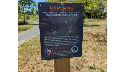
Restoration involves enhancing a formerly developed parcel through soil enrichment and plantings as well as engineering interventions to reduce flooding. Native plants and trees can be used to produce pocket parks, meadows or woodlands. The primer outlines specific methods and techniques for designing, implementing and maintaining a sustainable, ecologically based landscape resilience project.
“Resilient landscapes contribute to overall climate resilience by supporting the plants and animals that perform important ecological functions,” Maslo said. “Biodiverse landscapes mitigate flooding, retain soils, and protect critical infrastructure, such as hospitals and power stations.

Maslo said she hopes the guide will serve as a national model for action.
Creation of the primer was supported by the Rutgers Climate and Energy Institute, the New Jersey Agricultural Experiment Station and South Dakota State University, and with financial assistance from the DEP and the U.S. Department of Housing and Urban Development through the National Disaster Resilience Competition.


